2020 ASLA RESEARCH AWARD OF HONOR: Particulate Matter Mitigation Through Urban Green Infrastructure: Research on Optimization of Block
'Market research'表示市场调查,'SWOT analysis'是SWOT分析。 #生活技巧# #职场沟通技巧# #商务英语口语#
“从超本地化的层面看,街区尺度的绿色空间已被证明能够有效消减空气中颗粒物形式的污染物。通过对中国五个城市的37个场地进行长期的空气质量研究,该项目团队得出了三个改善空气质量的策略:在可利用的土地上建造口袋公园;通过屋顶干预和垂直绿化栽种已开发的土地;将较小的种植地块相互连接,以创造规模更大且更加连续的绿道。在一个街区中,改善空气质量的最好结果是将绿化覆盖率提高到30%左右;单独的街区彼此缝合得越多,对整体空气质量的影响也就越好。”
– 2020年评审委员会
“At the hyper-local level, block-sized green spaces have proven effective at reducing pollutants in the form of airborne particulate matter. A long-term air quality study of 37 sites spread across five cities in China found three strategies for improving air quality: creation of pocket parks in available land; planting of developed land through rooftop intervention and vertical greening; and connecting smaller planted parcels to each other to create larger, more continuous greenways. Within a block, the greatest air quality improvements came increasing green coverage to roughly 30 percent; the more of these blocks are stitched together, the better the overall air qualityimpact.”
– 2020 Awards Jury
来自 ASLA 对gooood的分享。
Particulate Matter Mitigation Through Urban Green Infrastructure: Research on Optimization of Block-scale Green Space | Huazhong University of Science and Technology
项目陈述
PROJECT STATEMENT
根据世界卫生组织的数据,世界上91%的人口生活在空气颗粒物污染过重的环境中,而粒径较小的颗粒物(如PM2.5)则是主要的污染物。过去的研究表明,城市绿色基础设施可以有效消减PM2.5,但从街区尺度来看,PM2.5的浓度存在着明显的差异。鉴于街区是城市设计的核心要素,在街区尺度内设计绿色基础设施可以有效实现消减PM2.5的目标。
项目团队对中国5个都市区域的绿色基础设施设计(如空间配置)进行了数量(如面积)和质量上的分析——包括景观设计指标和PM2.5长期数据的相关性——并在此基础上制定了优化的绿色基础设施设计策略。最后,这些策略被应用至一个典型的城市区域,并对绿色基础设施的性能进行了建模。从总体上看,这项研究有力地证明了,街区尺度的绿色基础设施设计在改善空气质量方面是有效的。其他面临类似空气质量问题的国家同样可以从此项研究中受益。
According to the World Health Organization, 91% of the world’s population lives in an environment that has excessive air particle pollution, and particulate matter with a smaller particle size (i.e., PM2.5) is the main pollutant. Previous studies suggested that urban green infrastructure is effective in mitigating PM2.5, while there are significant differences in PM2.5 concentration at the urban block scale. Because block is a central element of urban design, designing green infrastructure at the block scale can be effective in achieving PM2.5 mitigation goals.
We analyzed the quantity (e.g., area) and quality of green infrastructure design (e.g., spatial configuration) in five metropolitan areas in China, including correlation analyses of landscape design metrics and long-term PM2.5 data, and we further developed optimized green infrastructure design strategies. Last, we applied these strategies in a typical urban district and modelled the green infrastructure performance. In summary, this study provides strong evidence that green infrastructure design at the block scale is effective in improving air quality. Other countries that face similar air quality challenges can benefit from this research.
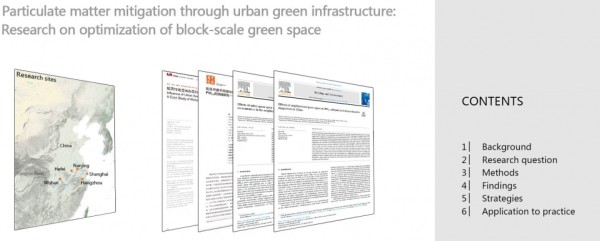
▲封面+内容:研究地点、研究出版物和目录。Cover + contents. Study locations, research publications, and table of contents © Jiafeng Wang
项目说明
PROJECT NARRATIVE
1. 研究背景
根据世界卫生组织的数据,世界上91%的人口生活在空气颗粒物污染过重的环境中,这种状况严重威胁着人的健康。粒径较小的特定物质(如PM2.5)是主要的污染物,这在发展中国家尤为典型。过去的研究表明,各种形式的城市绿色基础设施可以通过植物带来的沉积、阻滞和吸收作用有效地消减PM2.5。通过分析长期的监测数据,本次研究发现,PM2.5的浓度在不同的城市街区之间存在显著的差异,波动范围在80%-120%之间。鉴于街区是城市设计的核心要素,在街区尺度内设计绿色基础设施可以有效实现降低PM2.5的目标。
2. 研究方法
设计团队将地处长江中下游的五个省会城市——合肥、上海、南京、杭州和武汉选为研究地点。这些城市都具有夏热冬冷的气候特征,拥有相似的已建城区、地貌和城市形态,空气污染的严重程度亦不相上下。这些城市还广泛分布着现成的空气质量监测站,这也使它们成为了分析绿色基础设施以及PM2.5改善方法的理想选择。在对选定场地进行数据筛选和实验控制后,37个典型的城市街区被选为实施统计分析的对象,其中,绿色基础设施的尺度和空间模式是主要的自变量。每个典型城市街区是基于一个1km × 1km的网格而定义的,在网格大约中心的位置设有一个空气质量检测站。详细的步骤见下文。
PM2.5:PM2.5数据以“每小时的PM2.5浓度”为表达形式,是从中国国家环境监测中心已运行两年的监测站获取而来。这些监测站提供了一个开放的渠道,可以获得准确且充足的空气质量数据。五个城市的PM2.5数据是基于相同的标准进行测量的,并且使用了三个相对指标(范围、持续时间和比例),因此在分析中具有可比性。
绿色基础设施的尺度和模式:借助0.8m的高分辨率遥感影像,项目团队确定了绿色基础设施的数量和空间分布。通过对象导向的分类方法和遥感反演方法,分别得到了绿地覆盖率和三维(3D)绿化率,这两个数据共同展现了绿色基础设施的采纳规模。接下来是通过“空间形态模式分析”(MSPA),将绿色基础设施的空间模式可视化:它们将与城市结构相互交叠,并呈现为七个模式等级。
定量分析:设计团队对绿色基础设施的覆盖率和PM2.5浓度的相关性进行了分析。“曲线拟合分析”被用来最终定义一个可能的绿色覆盖率阈值,使绿色基础设施的性能最大化。而通过“逐步回归分析”,七个模式等级及其对降低PM2.5浓度的相对贡献均得到了量化。
3. 结论
绿色基础设施数量与PM2.5浓度间的关系:增加街区尺度的绿地覆盖率可以有效降低PM2.5浓度;当绿地覆盖率增加至30%左右时,降低效果最为明显。增加街区尺度的三维绿化可有效降低PM2.5浓度;当三维绿化密度增加至1.44公顷/公顷土地面积时,降低效果最为明显。
绿色基础设施空间模式与PM2.5相对浓度间的关系:通过对7个MSPA等级的分析,项目团队发现其中有5个等级可以有效降低PM2.5浓度,其中核心区、桥梁和小岛这三个空间形态的影响最强。增加核心区和桥梁MSPA等级的比例可以降低PM2.5浓度。减少小岛MSPA等级的比例也可以降低PM2.5的浓度。
4. 设计策略总结
基于目前的研究,项目团队提出了三条操作则略:(1)在街区尺度下,通过改造空地、闲置土地和其他可利用的土地区域来创建口袋公园;(2)通过屋顶绿化、垂直绿化和立面绿化等方式增加城市街区的三维绿化;(3)通过缝合相邻的多个小型绿地来提高城市街区绿色基础设施的联结度,使之成为连续的绿化走廊和绿道。
5. 基于研究结果的项目应用
武汉市江汉区的总面积为28.29平方公里,有68万人口。该区可被看做是武汉老城区遭受严重空气污染的一个典型缩影。它包含广泛的城市街区单元;现有的绿色基础设施数量有限且高度分散。在对绿色基础设施覆盖率、三维绿化以及MSPA等级进行分析后,项目团队采用了研究得出的设计策略,并提出建设绿道,通过充分利用闲置土地来增加地面绿化,同时增强屋顶和垂直绿化。绿色空间的覆盖率从23.35%提高至29.96%,具体来看,核心区域MSPA等级比例增加了5.84%,桥梁MSPA等级比例增加了1.15%,而小岛MSPA等级比例则相应地减少了4.62%。模型分析显示,达到标准的天数预计将增加32天。
6.意义
通过对中国的5个特大城市的绿色基础设施设计(如空间配置)进行数量(如面积)和质量上的分析,项目团队将景观设计指标与空气质量检测的长期数据关联起来,并制定了优化的、能显著消减PM2.5的绿色基础设施设计策略。总体而言,本次研究提供了强有力的证据,证明微观尺度(如街区)下的景观设计在改善空气质量方面是有效且高效的。其他面临类似空气质量问题的国家同样可以从此项研究中受益。
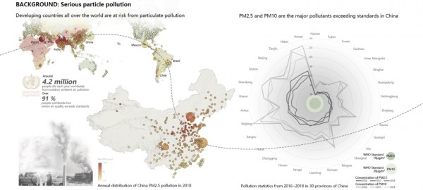
▲背景:严重的颗粒物污染。根据世界卫生组织的数据,世界上91%的人口生活在空气颗粒物污染过重的环境中,该状况在发展中国家尤甚,这其中也包括中国的许多城市。Background: Serious particle pollution. According to the World Health Organization, 91% of the world’s population lives in an environment that has excessive air particle pollution. Cities in developing countries suffer the most, including many in China.© Peiyuan Sun
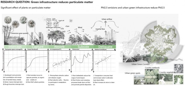
▲研究问题:通过绿色基础设施减少颗粒物。各种形式的城市绿色基础设施可以通过植物带来的沉积、阻滞和吸收作用有效地消减PM2.5。Research question: Green infrastructure reduces particulate matter. Urban green infrastructure in various forms of designed landscapes are effective in mitigating PM2.5 through sedimentation, retardation, and absorption functions provided by plants.© Jiafeng Wang and Lu Ding
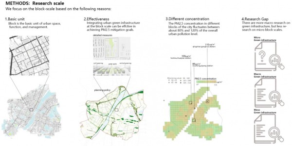
▲方法:研究尺度。从街区尺度来看,PM2.5的浓度存在着明显的差异。鉴于街区是城市设计的核心要素,在街区尺度内设计绿色基础设施可以有效实现降低PM2.5的目标。Methods: Research scale. There are significant differences in PM2.5 concentration at the urban block scale. Because block is a central element of urban design, designing green infrastructure at the block scale can be effective in achieving PM2.5 mitigation goals.© Wenpei Li
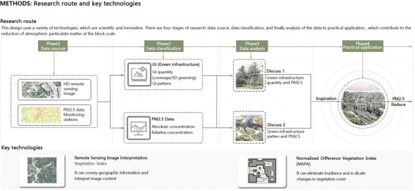
▲方法:研究路径和关键技术。研究分四个步骤进行:数据来源确定、数据收集、数据处理和实际应用。研究中使用了两种关键技术:ENVI高分辨率遥感图像分类法和“空间形态模式分析”(MSPA)。Methods: Research route and key technologies. The study was carried out in four phases: data source determination, data collection, data processing, and practical application. Two key methods are used: ENVI high-resolution remote sensing imagery classification, morphological spatial pattern analysis (MSPA).© Lu Ding
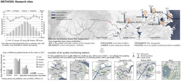
▲方法:研究地点。研究的地点包括中国长江中下游地区的五个特大城市。这些城市具有相似的区域背景、气候条件、人口规模、空气污染程度和城市发展结构,并且都拥有可观的空气质量监测数据。Methods: Research sites. Study sites include five megacities in the middle- and lower-reaches of the Yangtze River in China. They share similar regional contexts, climatic conditions, population sizes, air pollution levels, urban development structures, and have good availability of air quality monitoring data.© Jiafeng Wang
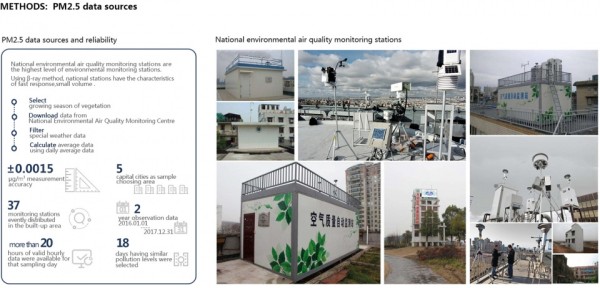
▲方法:PM2.5数据来源。PM2.5数据来自中国国家环境监测中心,涵盖了过去两年被记录下来的每小时PM2.5浓度水平。Methods: PM2.5 data source. PM2.5 data were obtained from the China National Environmental Air Quality Monitoring Centre. Data include the hourly PM2.5 concentration levels recorded in the past two years.© Jiafeng Wang
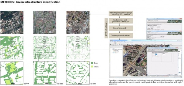
▲方法:绿色基础设施识别。基于目标观测图像分类方法,利用ENVI软件可从0.8米的高分辨率遥感图像中检索出绿色基础设施所在区域。Methods: Green infrastructure identification. Using the object observation imagery classification method, the green infrastructure areas were retrieved from the 0.8 m high-resolution remote sensing imagery using the ENVI software.© Jiafeng Wang

▲结论:绿色基础设施数量(绿化覆盖率)与PM2.5之间的关系。增加街区尺度的绿色基础设施覆盖率可以有效降低PM2.5浓度;当绿色基础设施覆盖率增加至30%左右时,降低效果最为明显。Findings: Relationships between green infrastructure quantity (green coverage) and PM2.5 concentration. Increasing the block-scale green infrastructure coverage can effectively reduce PM2.5 concentration. Increasing green infrastructure coverage to approximately 30% can maximize the PM2.5 mitigation effectiveness.© Lu Ding
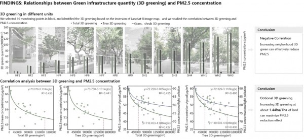
▲结论:绿色基础设施数量(三维绿化)与PM2.5之间的关系。增加街区尺度的三维绿化可有效降低PM2.5浓度;当三维绿化密度增加至约1.44公顷/公顷土地面积时,降低效果最为明显。Findings: Relationships between green infrastructure quantity (3D greening) and PM2.5 concentration. Increasing the block-scale three-dimension greening (3D greening) can effectively reduce PM2.5 concentration. Increasing 3D greening to approximately 1.44 ha per hectare land area can maximize PM2.5 reduction effect.© Lu Ding

▲结论:显著影响PM2.5的绿色基础设施空间模式与MSPA等级。MSPA是一种图像处理方法,可用于识别不同的绿色基础设施空间模式。项目团队发现有5个MSPA等级可以有效降低PM2.5浓度,其中核心区、小岛和桥梁这三个空间形态的影响最强。Findings: Green infrastructure spatial pattern and MSPA class that significantly influence PM2.5. MSPA is an image-processing method to identify different green infrastructure spatial patterns. Five MSPA classes have shown the ability to decrease PM2.5 concentration, especially the core, islet, and bridge.© Wenpei Li
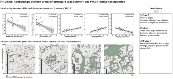
▲结论:绿色基础设施空间模式与PM2.5相对浓度间的关系。增加核心区和桥梁MSPA等级的比例可以降低PM2.5浓度。减少小岛MSPA等级的比例也可以降低PM2.5的浓度。Findings: Relationships between Green infrastructure spatial pattern and PM2.5 relative concentration. Increasing the proportions of the core and the bridge MSPA classes can decrease PM2.5 concentration. Decreasing the proportion of the island MSPA class can also decrease PM2.5 concentration.©Wenpei Li
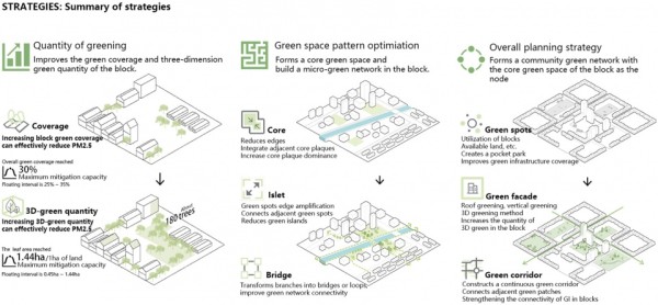
▲设计策略总结:基于绿色基础设施的数量和空间模式,项目团队制定出了消减PM2.5的设计策略,并对街区尺度的绿色空间优化策略进行了可视化。Strategies: Summary of design strategies. Design strategies of reducing PM2.5 based on green infrastructure quantity and spatial pattern are developed. In addition, strategies to optimizing green space at the block scale are visualized.© Peiyuan sun
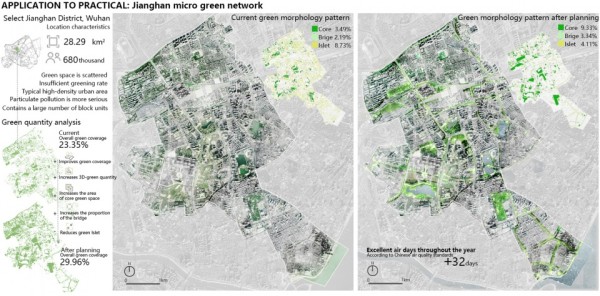
▲实际应用:江汉区微型绿网。武汉市江汉区的绿色基础设施设计,使绿地覆盖率增加了6.5%以上。模型分析显示,达到标准的天数预计将增加32天。Application to practical: Jianghan District micro green network. Green infrastructure design in Jianghan District, Wuhan, resulted in an increase of green space coverage by more than 6.5%. Modeling study showed that the number of days reaching standard is expected to be increased by 32 days.© Peiyuan Sun
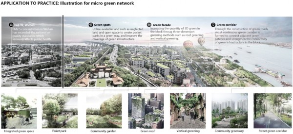
▲实际应用:微型绿网图解:具体采取的措施包括点状绿地、绿化外墙和绿化走廊,预计将显著提高江汉区的空气质量。绿色基础设施网络还可以提供休闲和娱乐等伴随效益。Application to practical: Illustration for micro green network. Specific strategies include green spot, green facade, and green corridor. It expects to significantly increase air quality of the Jianghan District. The green infrastructure network can also provide co-benefits such as leisure and entertainment.© Lu Ding
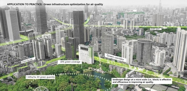
▲实际应用:绿色基础设施对空气质量的优化。在江汉区建造包含微型绿色基础设施网络的街区单元,能够改善城市区域的整体空气质量。其他面临类似空气质量问题的国家同样可以从此项研究中受益。Application to practical: Green infrastructure optimization for air quality. Constructing block units with micro-green infrastructure network in Jianghan District to improve the overall air quality in the urban area. Other countries that face similar air quality challenges can benefit from this research.© Peiyuan Sun
PROJECT NARRATIVE
1. Research background
According to the World Health Organization, 91% of the world’s population lives in an environment that has excessive air particle pollution, which condition seriously threatens people’s health. Particular matter with a smaller particle size (i.e., PM2.5) is the main pollutant, especially in developing countries. Previous studies have shown that urban green infrastructure in various forms of designed landscapes are effective in mitigating PM2.5 through sedimentation, retardation, and absorption functions provided by plants. Through analyzing long-term monitoring data, this current study found that PM2.5 concentration can vary significantly among different urban blocks, ranging from 80% to120%. Because block is a central element of urban design, planning and design at the block scale can be effective in achieving PM2.5 mitigation goals.
2. Research methods
We used five provincial capital cities in the middle- and lower-reaches of the Yangtze River in China as the study sites. These cities are Hefei, Shanghai, Nanjing, Hangzhou and Wuhan, all of them are part of the hot-summer/cold-winter climate zone. In addition, these cities have similar built-up urban areas, landforms, and urban morphology, and suffer from similar levels of severity of air pollution. The readily available air quality monitoring stations across these cities also make them ideal for the analysis of green infrastructure and PM2.5 mitigation. After data screening and experimental controls of the sites, 37 typical urban blocks were selected to perform the statistical analyses, with green infrastructure size and spatial pattern being the primarily independent variables. A typical urban block is defined based on a grid of 1km × 1 km that has an air quality monitoring station located approximately on the center. Detailed procedures are elaborated below.
PM2.5: PM2.5 data in the form of hourly PM2.5 concentration are retrieved from the monitoring stations installed and operated by the China National Environmental Monitoring Center for two years. These stations provide an open access to high precision and abundant air quality data. PM2.5 data of the five cities are comparable for the analysis because they are measured based on the same standards, and three relative indicators (range, duration, and rate) are used to represent the changes of PM2.5 concentration.
Scale and pattern of green infrastructure: Based on the 0.8m high-resolution remote sensing imagery, the quantity and spatial distributions of green infrastructure are identified. The green space coverage and the three-dimension (3D) greening are obtained via the object-oriented classification method and the remote sensing inversion method, respectively, which altogether represent the scale of green infrastructure adoption. Next, using the morphological spatial pattern analysis (MSPA) we visualized the spatial patterns of green infrastructure, which were overlaid against the urban fabric and were presented as seven pattern classes.
Quantitative analysis: Correlation analyses were conducted regarding the coverage of green infrastructure and PM2.5 concentration. Curve fitting analysis was used to ultimately define a possible threshold of green coverage that allows maximum green infrastructure performance. Through the stepwise regression analysis, the seven green infrastructure pattern classes and their relative contributions to PM2.5 concentration reduction are quantified.
3. Findings
Relationships between green infrastructure quantity and PM2.5 concentration
Increasing the block-scale green space coverage can effectively reduce PM2.5 concentration; the maximum reduction effect occurs when the green space coverage increases to approximately 30%. Increasing the block-scale 3D greening can effectively reduce PM2.5 concentration; increasing 3D greening density to about 1.44 ha per hectare land area can maximize the reduction effect.
Relations between Green infrastructure spatial pattern and PM2.5 relative concentration
Through the analysis of seven MSPA classes, we found that five of them can significantly reduce PM2.5 concentration, and among these the core, bridge, and islet have the strongest impact. Increasing the proportions of the core and bridge classes can decrease PM2.5 concentration. Decreasing the proportion of islet class can also decrease PM2.5 concentration.
4. Summary of design strategies
Three operational strategies are proposed based on this current research. (1) Create pocket parks through retrofitting vacant land, idle land, and other available land areas at the block scale to innovative green infrastructure designs; (2) Increase the 3D greening of urban blocks through roof greening, vertical greening, and other green facade; (3) Improve connectivity of green infrastructure in urban blocks through stitching adjacent green patches and make them continuous green corridors and greenways.
5. Project application based on research findings
Jianghan District, Wuhan, has a total area of 28.29 square km and a population of 680,000. This district is a typical snapshot of the old city in Wuhan that suffers from serious air pollution. The district contains extensive urban block units; current green infrastructure is limited and yet, highly fragmented. Following the analysis of the green infrastructure coverage percentage and the 3D greening and MSPA classes, we used the design strategies derived from the research and proposed the construction of greenways, making full use of the idle land areas for greening and increasing roof greening and vertical greening. The green space coverage has increased from 23.35% to 29.96%. Specifically, the proportions of the core MSPA class increased by 5.84%, the bridge MSPA class increased by 1.15%, and the island MSPA class reduced by 4.62%, respectively. Modeling analysis shows that the number of days reaching standard is expected to be in creased by 32 days.
6. Significance
Through analyzing the quantity (e.g., area) and quality of green infrastructure design (e.g., spatial configuration) in five metropolitan areas in China, we correlated landscape design metrics with long-term air quality monitoring data and developed optimized green infrastructure design strategies that can provide salient benefits of PM2.5 mitigation. In summary, this study provides strong evidence that landscape design at a micro scale (i.e., block) is effective and efficacious in improving air quality, and the research products can be used by other countries that face similar air quality challenges.
More: ASLA;Huazhong University of Science and Technology
网址:2020 ASLA RESEARCH AWARD OF HONOR: Particulate Matter Mitigation Through Urban Green Infrastructure: Research on Optimization of Block https://www.yuejiaxmz.com/news/view/767491
相关内容
Review on the control and mitigation strategies of lake cyanobacterial bloomsResearch progress of ecological space and ecological land in China
《太原电动出租车推广案例分析及对其他城市的建议》
Research progress on the quality of life of the elderly and its influencing factors
Research and Prospects of Smart Home Communication Security
Research process on decision
多元重塑激活内生动力 小城镇旧城更新的永新实践
基于改进DE的城轨列车节能速度曲线研究
Research progress in the relationship between gut microbiota and food allergy in children
面向居民出行需求的公交服务网络优化
随便看看
最新动态分享
- DIY卫生间装修零基础教程10大避坑指南与省钱攻略,手把手教你打造高性价比卫生间
- 洗手间DIY装修全攻略:零基础小白也能轻松完成,省下万元预算
- DIY卫生间装修全攻略:5步搞定实用又高颜值浴室,附避坑指南(附材料清单)
- ️厕所装修避坑指南零基础手把手教你DIY省下2W!附水电改造防水防滑全攻略
- 厨房和洗手间如何装修diy
- 浴室干湿分离+养生三件套=健康生活新标配!亲测有效的5大设计法则
- 客厅玩具区装修全攻略:儿童房DIY设计技巧与收纳方案(附预算清单)
- 最火的设计!儿童房涂鸦墙DIY全攻略:零基础也能打造高颜值艺术角?附避坑指南
- 儿童房全屋定制效果图大全
- 客厅背景墙设计新趋势|卧室儿童房壁画DIY指南|低成本打造高颜值家居
热点动态分享
- 138519
- 40879
- 36491
- 25641
- 24767
- 23855
- 21585
- 16472
- 15078
- 15040